FOSSPicks
Route Planning
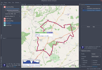
QMapShack 1.8
OpenStreetMap is a wonderful exception in an area that's blighted by proprietary software and content. In the UK, even the tax payer funded "Ordnance Survey" locks down its content behind paywalls and restrictive use clauses, which is a real lost opportunity for open source-like innovation. OpenStreetMap has helped fill such gaps in the UK and all over the world, helping people in crisis, such as the Humanitarian OpenStreetMap team in Haiti, as well as people lost in the mountains. The data is always growing in depth, accuracy, and influence.
Open source apps, such as Osmand and QMapShack, are a brilliant way of making use of all this data, allowing you to follow routes or find where you are. Unlike Osmand on Android, QMapShack is built for the desktop and is perfect for editing routes and diving into the details of what a map offers. It was never built specifically for OpenStreetMap data, being a sequel of sorts to QLandkarte, which was built primarily to access Garmin maps, but it supports OSM natively, along with various other map formats. When first launched, QMapShack guides you through getting access to these maps as soon as possible, caching maps locally and easily from OpenStreetMap. You can even search Google and see any resultant location in the main view. QMapShack's great strength, however, is in editing and creating routes. You can import a GPX file from Osmand, for instance, and study the height contours or edit the waypoints in a fast, responsive user interface that's much easier to use than a web portal. It's exactly the kind of third-party tool OpenStreetMap is missing on the Linux desktop and is the best way I've found to prepare a route for a bike ride or a walk in the hills – exactly the kind of application you'd be expected to pay for on other platforms.
Project Website
https://bitbucket.org/maproom/qmapshack
Secure Erase
Buy this article as PDF
(incl. VAT)
Buy Linux Magazine
US / Canada
UK / Australia