FOSSPicks
Satellite imagery
felicette
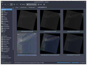
We've all become desensitized to the miracle of pervasive access to satellite imagery from various online mapping services. It's a brilliant way to be a virtual tourist, to check out a location before you travel, or even to see how much your hometown has changed since you left for college. But when it comes to experimentation, their cloud data is distant and unobtainable from our Linux boxes. There's obviously OpenStreetMap, which can help, and KDE's Marble has various layers with satellite imagery, but nothing if you want to access some real detail or image data that's more timely. Which is when felicette can help. This is a command-line tool for downloading very high resolution satellite imagery from the NASA/USGS prestigious Landsat satellite imaging array, which is constantly taking 115-mile-wide photos of the Earth at almost every location, day and night.
The command couldn't be simpler to use. Type felicette -l "London", for example, to grab the latest images of the UK's capital. Being simple to use doesn't mean it's simply downloading the images though. In the background, felicette is downloading blue, green, and red band wavelength imagery and stacking these with different tools to create the final composite JPEG and TIFF, the latter of which is typically 350MB in size. If you want London, Ontario, then you can use latitude and longitude coordinates instead, such as felicette -c 43 -81.25. There are two further options for enhancing the image: the first by adding the panchromatic band, and the second by adding an infrared layer to highlight vegetation. Thanks to the high resolution of the images, and the fact that they're normally recent, felicette is the perfect way to automate image collection for a specific area you're interested in, so you can then compare changes over time. But it's just as useful if you want to see how your hometown has changed.
Project Website
https://github.com/plant99/felicette
File explorer
Buy Linux Magazine
US / Canada
UK / Australia