Map projection on a two-dimensional terminal with Go
Programming Snapshot – Go Map Projections

© Photo by Don Pinnock on Unsplash
While searching for a method to draw geodata right into the terminal, Mike Schilli discovers the wondrous world of map projections.
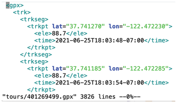
While I was working on hikefind, a command-line program that chooses a trail from a collection of GPX files with track points, for a recent issue [1], I got the idea of drawing the trail contours the program found in a terminal window. Unfortunately, a GPX file generated by an app such as Komoot or a Garmin tracker only contains geocoordinates as floating-point numbers. They refer to the points of the globe through which the trail passes (Figure 1).

These geopoints on a spherical surface now need to be converted to a two-dimensional coordinate system so that they look as natural as possible on a flat map. This problem was solved centuries ago. Any map, whether paper or digital, is based on the genius idea of projecting geopoints on the globe, which are available as latitude and longitude values, onto an XY coordinate system on a plane.
[...]
Buy this article as PDF
(incl. VAT)
Buy Linux Magazine
Subscribe to our Linux Newsletters
Find Linux and Open Source Jobs
Subscribe to our ADMIN Newsletters
Support Our Work
Linux Magazine content is made possible with support from readers like you. Please consider contributing when you’ve found an article to be beneficial.

News
-
New Linux Botnet Discovered
The SSHStalker botnet uses IRC C2 to control systems via legacy Linux kernel exploits.
-
The Next Linux Kernel Turns 7.0
Linus Torvalds has announced that after Linux kernel 6.19, we'll finally reach the 7.0 iteration stage.
-
Linux From Scratch Drops SysVinit Support
LFS will no longer support SysVinit.
-
LibreOffice 26.2 Now Available
With new features, improvements, and bug fixes, LibreOffice 26.2 delivers a modern, polished office suite without compromise.
-
Linux Kernel Project Releases Project Continuity Document
What happens to Linux when there's no Linus? It's a question many of us have asked over the years, and it seems it's also on the minds of the Linux kernel project.
-
Mecha Systems Introduces Linux Handheld
Mecha Systems has revealed its Mecha Comet, a new handheld computer powered by – you guessed it – Linux.
-
MX Linux 25.1 Features Dual Init System ISO
The latest release of MX Linux caters to lovers of two different init systems and even offers instructions on how to transition.
-
Photoshop on Linux?
A developer has patched Wine so that it'll run specific versions of Photoshop that depend on Adobe Creative Cloud.
-
Linux Mint 22.3 Now Available with New Tools
Linux Mint 22.3 has been released with a pair of new tools for system admins and some pretty cool new features.
-
New Linux Malware Targets Cloud-Based Linux Installations
VoidLink, a new Linux malware, should be of real concern because of its stealth and customization.
