Go retrieves GPS data from the komoot app
Programming Snapshot – Go GPS Data Retrieval

© Lead Image © Nataliia Natykach, 123RF.com
The hiking and cycling app komoot saves your traveled excursion routes. Mike Schilli shows you how to retrieve the data with Go.
As we all know, the past year and a half were completely lost to the pandemic. Because of various lockdowns, there wasn't much left to do in your leisure time in terms of outdoor activity. Playing soccer was prohibited and jogging with a face covering too strenuous. This prompted my wife and me to begin exploring areas of our adopted city, San Francisco. We hiked hidden pathways, previously unknown to us, every evening on hour-long neighborhood walks. To our amazement, we discovered that even 25 years of living in a city is not enough to explore every last corner. We found countless little hidden stairways, unpaved paths, and sights completely unknown to major travel guides.
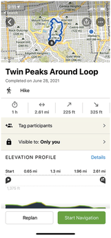
Memorizing all the turnoffs for these newly invented, winding city hiking trails is almost impossible, but fortunately a mobile phone can step in as a brain extension here. Hiking apps plan your tours, record your progress during the walk, display traveled paths on a online map, and allow for sharing completed tours with friends (Figure 1). One of the best-known hiking (and biking) apps is the commercial komoot, which is based on OpenStreetMap data and remains free of charge as long as the user gets invited by another (even new) user and limits themselves to one local hiking area.
[...]
Buy this article as PDF
(incl. VAT)