Online services that extend the capabilities of OpenStreetMap
Useful

A variety of online services rely on the data collected by the OpenStreetMap project. This article introduces you to the most useful options.
OpenStreetMap (OSM) [1] is one of the largest and most popular community web projects. In contrast to a tool like Wikipedia, however, OSM users rarely see the project's website. Instead, geo-information systems such as route planners, navigation apps and devices, or outdoor trackers integrate OSM's data as part of their own presentation.
If you visit the OSM website directly, you can click on the Layers button on the right side to display alternative map forms, such as Cycle Map, Transport Map, or Humanitarian Map (Figure 1). In addition, you can display current information about the maps by checking the Map Notes checkbox. The contents are shown as soon as you mouse over or click on the little flag in the map. Many layers come with legends that you can enable by clicking on the button with the i to the right of the map.
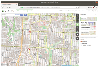
Unlike commercial map services like Google Maps or Bing Maps, OSM lets you export your map data. Be sure to comply with copyright and license requirements [2]. Some forms of data are available using the Export button in the top left corner of the OSM main view. If you want to save the map image, click on the Share button in the sidebar (Figure 2). OSM supports several image formats, including PNG or JPG, but also artifact-free scalable vector graphics in SVG and PDF formats.
SVG is particularly well-suited for further processing, typically with supporting applications such as Inkscape. If you prefer Gimp, make sure you enable the Import paths option when importing. Import paths gives you direct access to all the fonts, lines, and other elements of the map.
The easy availability of OSM data means other projects can build their own mapping services around the large and comprehensive OSM dataset. A community group could create a project that focuses on a specific feature or activity or provide value-added data for a specific region. In the true spirit of open source, some of these services tie back in with OSM and are available directly from the OSM interface in addition to having their own homepages.
This article tours some services that make use of OSM data. I'll also highlight some useful options within the OSM user interface that provide additional information for users with specific needs.
OpenCycleMap
OpenCycleMap [3] is a map tool for cyclists. You can access OpenCycleMap through OSM or via the project's own homepage. OpenCycleMap is drawn sparingly and commented even more sparingly. However, the map highlights cycle paths and identifies official long-distance paths (Figure 3).
Like OSM, OpenCycleMap is continuously updated. Route changes such as construction detours are often reflected in the map within only a few days. The map is also suitable for planning some longer tours. OpenCycleMap identifies points of interest such as shelters and sheds, water points and wells, bicycle shops, and some cafés and restaurants.
Waymarked Trails
If you are planning longer cycle tour in Europe or a tour on long-distance cycle route, such as the North Sea Cycle Route (EuroVelo 12) [4], it is easier to find your way around with the help of specialized sites such as Waymarked Trails [5] and other long-distance alternatives [6]. Waymarked Trails offers a path through well-known and signposted routes for hiking, cycling, MTB, ski touring, or skating (Figure 4).
The actual use of Waymarked Trails is only revealed when you zoom into an area and use the Routes button (bottom right) to find the marked routes available in the displayed area. In the detail view, the page also offers a download option in the form of a GPX track for most routes.
Although its European maps are far more comprehensive, Waymarked Trails does include some major routes in North America.
Naviki
For a long time, Naviki [7] was regarded as an "insider tip" among route planners for bicycles, since the project was developed at Münster University of Applied Sciences and did not pursue any commercial interests. In the meantime, however, the site has been further developed and is hosted by Beemo GmbH, a spin-off of the Laboratory for Software Engineering at Münster University of Applied Sciences.
Naviki's charm lies in the simple operation of the software, especially on computers with a large display. It is very easy to create a cycle route: First, right-click on the map to mark the start and destination. Then select the desired vehicle type (Figure 5). Everyday creates medium-length routes that try to avoid major roads. Shorter Route does the opposite: In order to minimize the route length, this option even integrates major roads into the route.
The other variants: Racing bike, Mountain bike, Leisure, or S-Pedelec (see "S-Pedelec" box) have appropriate effects. Each of these options implements a specific set of routing rules, so that the resulting routes can differ significantly in length, altitude, and road type (single trail, cycle path, or country road). Naviki does not go further into the details of the routing algorithm. It is therefore a good idea to first get a feeling for how it works by creating routes in familiar territory.
S-Pedelec
As one of only a few bicycle route planners, Naviki offers an option to create routes especially for S-Pedelecs. An S-Pedelecs is an e-bike that can travel at speeds of up to 45kph. Traffic laws differ depending on the jurisdiction, but from a legal standpoint, an S_Pedelec is considered more like a moped than a bicycle.
Automatic route planning with Naviki produces useful to good route suggestions, but for the "perfect" bike tour, you usually have to adjust the route a little by hand. Grab the route with the mouse pointer and drag the tour to the desired waypoint. Naviki then automatically adjusts the route to the new specification. The rules activated by the defaults continue to apply. You can find a list of all the waypoints inserted in this way in the history via the buttons. The waypoints can be moved or removed later using the small x button to the right of each entry in the list.
Below the buttons for the route type is a fair amount of additional information: In particular, you will find the current route length and a height profile. If necessary, points of interest such as bike shops, inner-tube vending machines, or drinking water sources can be activated using the buttons in the top right corner of the map view (Figure 6). Use the button below to switch between the standard OSM, the OpenCycleMap, and a satellite view.
Once you are satisfied with the route, export the route. Click on the download symbol above the altitude profile. This symbol will open a dialog where you can choose the different formats. Naviki supports the most important data formats for navigation devices, including KML, GPX, OVL, and TCX.
Buy this article as PDF
(incl. VAT)
Buy Linux Magazine
Subscribe to our Linux Newsletters
Find Linux and Open Source Jobs
Subscribe to our ADMIN Newsletters
Support Our Work
Linux Magazine content is made possible with support from readers like you. Please consider contributing when you’ve found an article to be beneficial.
News
-
Halcyon Creates Anti-Ransomware Protection for Linux
As more Linux systems are targeted by ransomware, Halcyon is stepping up its protection.
-
Valve and Arch Linux Announce Collaboration
Valve and Arch have come together for two projects that will have a serious impact on the Linux distribution.
-
Hacker Successfully Runs Linux on a CPU from the Early ‘70s
From the office of "Look what I can do," Dmitry Grinberg was able to get Linux running on a processor that was created in 1971.
-
OSI and LPI Form Strategic Alliance
With a goal of strengthening Linux and open source communities, this new alliance aims to nurture the growth of more highly skilled professionals.
-
Fedora 41 Beta Available with Some Interesting Additions
If you're a Fedora fan, you'll be excited to hear the beta version of the latest release is now available for testing and includes plenty of updates.
-
AlmaLinux Unveils New Hardware Certification Process
The AlmaLinux Hardware Certification Program run by the Certification Special Interest Group (SIG) aims to ensure seamless compatibility between AlmaLinux and a wide range of hardware configurations.
-
Wind River Introduces eLxr Pro Linux Solution
eLxr Pro offers an end-to-end Linux solution backed by expert commercial support.
-
Juno Tab 3 Launches with Ubuntu 24.04
Anyone looking for a full-blown Linux tablet need look no further. Juno has released the Tab 3.
-
New KDE Slimbook Plasma Available for Preorder
Powered by an AMD Ryzen CPU, the latest KDE Slimbook laptop is powerful enough for local AI tasks.
-
Rhino Linux Announces Latest "Quick Update"
If you prefer your Linux distribution to be of the rolling type, Rhino Linux delivers a beautiful and reliable experience.