Optimizing and visualizing GPS data
Climbing Aid
Handheld navigation devices point the way and continuously record your position while you are walking. With a few scripts on Linux, extreme climber Mike Schilli attractively visualizes the data from some of his bold first ascents.
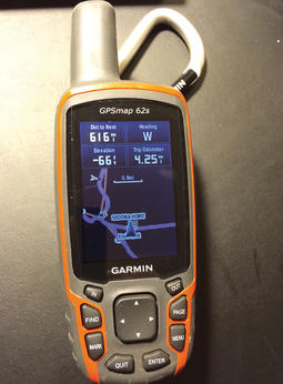
Every smartphone features a GPS receiver nowadays, and a generous collection of apps are guiding hikers across hill and dale by displaying maps. Of course, things can be pretty rustic out there in the wild, and it is a good idea to use more robust, water-splash protected devices with more powerful batteries. Some time ago, I purchased a Garmin 62s – on special offer. Although it might be a little outmoded by now, it looks as if you could drive a tank over it without causing any damage.
If you are spoiled by years of intuitive on-screen operation with your smartphone, you will probably be rubbing your eyes in disbelief to discover that LCD displays with weird menu designs – in which the user has to steer the cursor with a dozen plastic buttons on the front of the device – really do still exist (Figure 1).
[...]
Buy this article as PDF
(incl. VAT)