Get hiking suggestions from your recorded tours
Colorful and in Color
To make the meta values of the printed tours more eye-catching later on, Listing 5 initially includes the fatih/color package from GitHub, which provides functions to output the ANSI color codes commonly used by terminals.
You can compile Listings 4 and 5 with the usual three-card trick (Listing 6). The resulting hikefind binary either outputs all tours (Figure 5, without command-line options) or gives you a more compact selection using arbitrary combinations of the different filter types.
Listing 6
Compiling
$ go mod init hikefind
$ go mod tidy
$ go build hikefind.go csvread.go
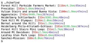
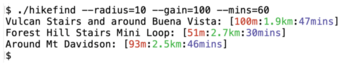
Figure 6 shows all the hiking trails within 10 kilometers of my adopted hometown of San Francisco that climb less than 100 meters in elevation and can be completed in one hour or less. Only three routes remain – it's a pretty hilly city after all.
Infos
- "Go Retrieves GPS Data from the Komoot App" by Mike Schilli, Linux Magazine, issue 252, November 2021, https://www.linux-magazine.com/Issues/2021/252/Plan-Your-Hike/(language)/eng-US
The Author

Mike Schilli works as a software engineer in the San Francisco Bay Area, California. Each month in his column, which has been running since 1997, he researches practical applications of various programming languages. If you email him at mailto:mschilli@perlmeister.com he will gladly answer any questions.
« Previous 1 2 3
Buy this article as PDF
(incl. VAT)
Buy Linux Magazine
US / Canada
UK / Australia
Subscribe to our Linux Newsletters
Find Linux and Open Source Jobs
Subscribe to our ADMIN Newsletters
Support Our Work
Linux Magazine content is made possible with support from readers like you. Please consider contributing when you’ve found an article to be beneficial.

News
-
Canonical Releases Ubuntu 24.04
After a brief pause because of the XZ vulnerability, Ubuntu 24.04 is now available for install.
-
Linux Servers Targeted by Akira Ransomware
A group of bad actors who have already extorted $42 million have their sights set on the Linux platform.
-
TUXEDO Computers Unveils Linux Laptop Featuring AMD Ryzen CPU
This latest release is the first laptop to include the new CPU from Ryzen and Linux preinstalled.
-
XZ Gets the All-Clear
The back door xz vulnerability has been officially reverted for Fedora 40 and versions 38 and 39 were never affected.
-
Canonical Collaborates with Qualcomm on New Venture
This new joint effort is geared toward bringing Ubuntu and Ubuntu Core to Qualcomm-powered devices.
-
Kodi 21.0 Open-Source Entertainment Hub Released
After a year of development, the award-winning Kodi cross-platform, media center software is now available with many new additions and improvements.
-
Linux Usage Increases in Two Key Areas
If market share is your thing, you'll be happy to know that Linux is on the rise in two areas that, if they keep climbing, could have serious meaning for Linux's future.
-
Vulnerability Discovered in xz Libraries
An urgent alert for Fedora 40 has been posted and users should pay attention.
-
Canonical Bumps LTS Support to 12 years
If you're worried that your Ubuntu LTS release won't be supported long enough to last, Canonical has a surprise for you in the form of 12 years of security coverage.
-
Fedora 40 Beta Released Soon
With the official release of Fedora 40 coming in April, it's almost time to download the beta and see what's new.