Mapping the details
Tutorial – Map Machine and OpenStreetMap
Use Map Machine's icons to make the most of OpenStreetMap data and show as many map features as possible.
OpenStreetMap (OSM) [1] is an open source success story, a tool that every owner of any kind of computing device has surely used at least once, knowingly or not. This collectively designed digital map of the whole world is, in fact, integrated into services by the likes of Wikipedia, Amazon, Apple, Facebook, and countless other organizations. Besides being a lot of fun, knowing how to handle OSM maps or raw geographical data from OSM is one of those skills that can likely be useful for everyone, sooner or later. This is why I present Map Machine [2], a tool you can use – by combining its set of icons with raw OSM data – to create your own custom maps.
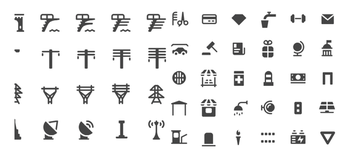
The Map Machine icon set aims to display as many map features as possible, because the original idea behind the project was to show all the richness of the OpenStreetMap data. Figure 1 shows just a small part of the complete icon set, and yet it covers features as diverse as barber shops, diving platforms, power lines, trellises, and mailboxes.
[...]
Buy this article as PDF
(incl. VAT)
Buy Linux Magazine
Subscribe to our Linux Newsletters
Find Linux and Open Source Jobs
Subscribe to our ADMIN Newsletters
Support Our Work
Linux Magazine content is made possible with support from readers like you. Please consider contributing when you’ve found an article to be beneficial.

News
-
Gnome Working on Test Center App to Make Testing Easier
It's now possible to test experimental features on the Gnome desktop without worrying that you'll break things.
-
New Vulnerability Discovered in Linux Kernel
Hiding out for nearly 15 years, the Ghostlock vulnerability allows a standard logged-in user to gain root privileges.
-
New Linux Flaw Lets Attackers Escape VMs
A 16-year-old vulnerability allows an attacker to escape a virtual machine, gain access to the host, and execute malicious code.
-
Hannah Montana Linux Is Back!
Developer Noah Cagle decided the world needed the once obscure but beloved Linux distribution and gave it a decidedly pink refresh.
-
System76 Refreshes the Lemur Laptop
If you're looking for a laptop with tons of power and battery, look no further than the latest iteration of the System76 Lemur Pro.
-
More than 43 Million Lines of Code in Linux Kernel 7.2
Using the cloc utility, Michael Larabel of Phoronix discovered that Linux kernel 7.2 has over 43 million lines of code.
-
Kubuntu Focus Goes Ultra
The Kubuntu Focus team has upped the performance ante of its M2 and Zr laptops with the latest, greatest CPUs from Intel.
-
Linux Gamers May Soon See Less Mouse Lag in KDE Plasma
Gamers using KDE’s Plasma desktop have been suffering from a slight input delay in mouse movement that could lead to getting fragged.
-
Three Lines of Code Improve Linux Storage Performance
A developer changed three lines of code, giving Linux storage performance a 5% bump.
-
AUR Hit Again with Malicious Packages
Once again the Arch User Repository is plagued by a high volume of malicious packages.